Tranvia
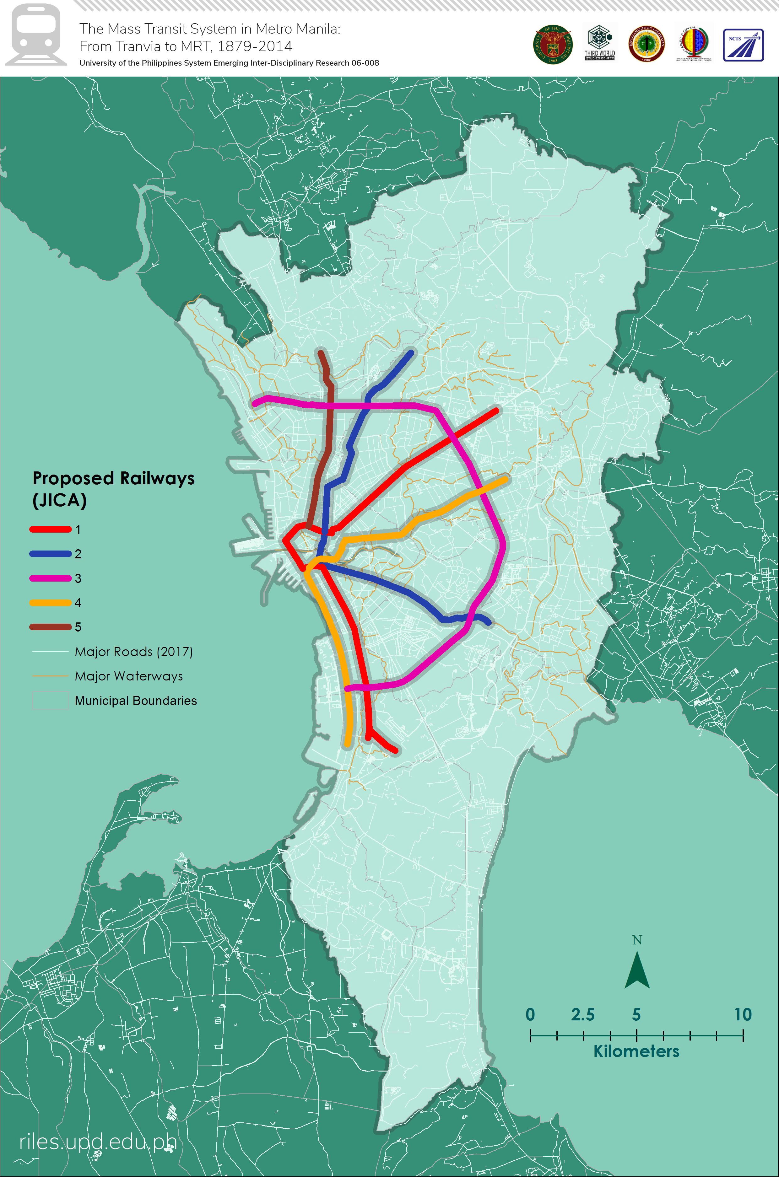
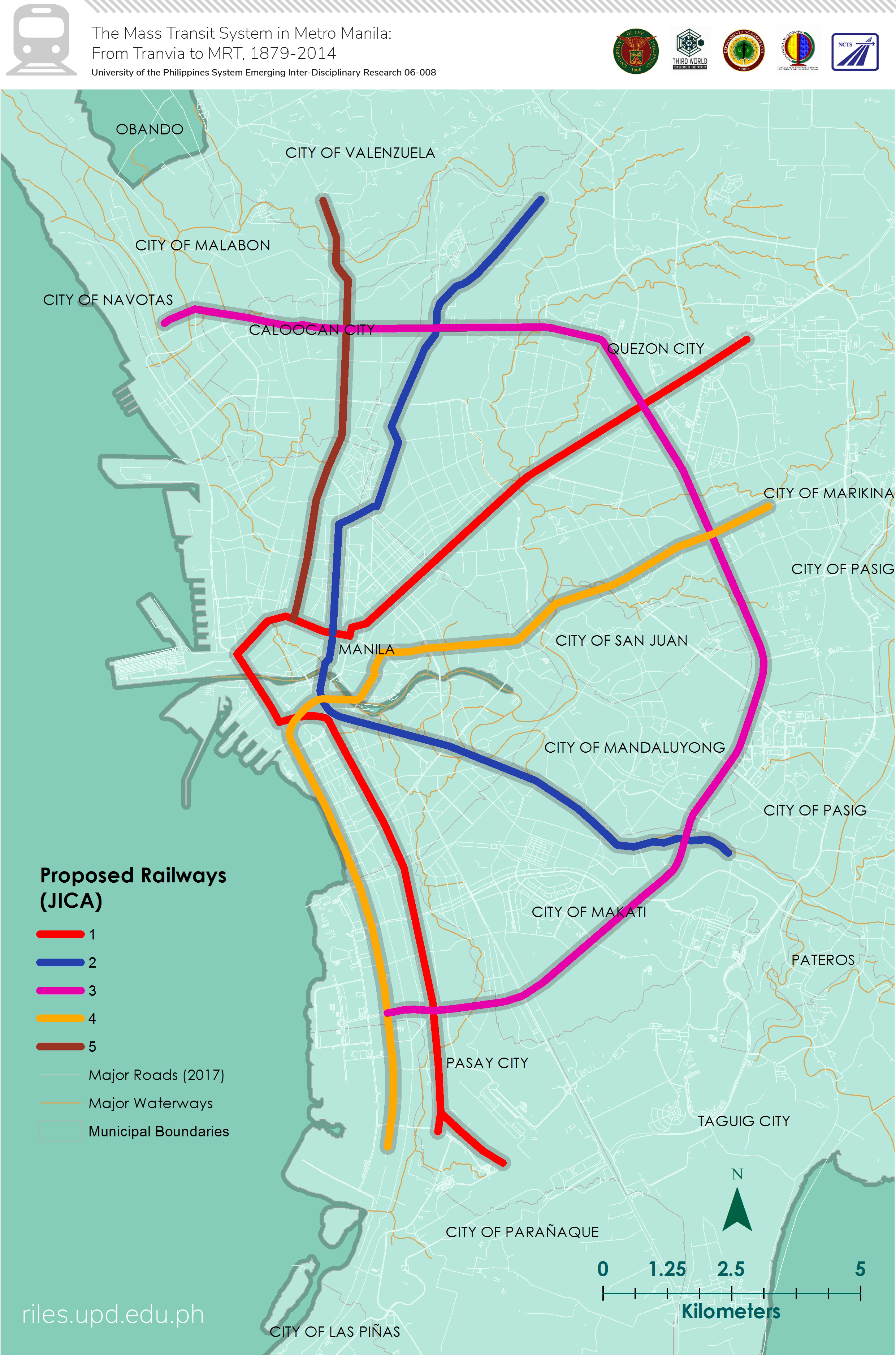
JICA Plan
| 3 | This is the tranvia railway configuration as of 1895 toward the end of Spanish rule in the Philippines. These were traversed by horse-drawn tranvias. |
| 4 | The tranvia lines as of 1905 were operated by MERALCO. These follow closely the lines proposed and granted franchise with under the Philippine Commission Act 484 |
| 5 | The tranvia lines of 1925 is arguably the peak of the length and density of the street car system. |
| 6 | The Metro Manila Transport, Land Use, and Development Planning Project (MMETROPLAN) of 1977 focused on building and improving roads in and around Metro Manila. |
| 7 | The nipa districts are usually the low-economic activity and high-population areas of historical Manila. The radial form of the tranvia lines at these areas bridge the workforce population to the city center. |
| 8 | These maps of 1903 and 1908 show the respective populations of each historical district in Manila. The concentration of the population does not dictate where the concentrations of the lines were. Instead, the lines are more intense and interconnected at the central business districts. |
| 9 | Maps 9-13 are time snapshots of Metro Manila’s population in recent history. There is a noticeable trend of gravitation towards the City of Manila |
| 10 | Maps 9-13 are time snapshots of Metro Manila’s population in recent history. There is a noticeable trend of gravitation towards the City of Manila |
| 11 | Maps 9-13 are time snapshots of Metro Manila’s population in recent history. There is a noticeable trend of gravitation towards the City of Manila |
| 12 | Zoomed version of the roposed monorail network (1969) |
| 13 | Proposed monorail network (1969) |
| 14 | These are time snapshots of the co-developing tranvia railway system and the Manila Railroad Company interurban lines from 1895 to 1945. It also shows at the backdrop a generalized imagery of how the built-up areas in Manila and its suburbs changed over time. |
| 15 | This is a map of the proposed Monorail by planner Sigurd Grava in 1972. |
| 16 | This is a map of the proposed Monorail by planner Sigurd Grava in 1972. |
| 17 | This two maps compare the extent of built-up area and the tranvia network of 1895 and 1925. The development of the lines seemed to coincide with the growth of built-up areas. |
| 18 | This is a map of the proposed Rapid Transit Railway (RTR) under the Urban Transport Study in Manila Metropolitan Area (UTSMMA) in 1973. |
| 19 | Proposed Electric Tranvia Lines as of 1897, approved and given franchise to operate under Act 484 of the Philippine Commission |
| 20 | Towns with stations of the interburban Manila Railroad Company (MRC) as of 1908. The line was from Manila to Dagupan. |
| 21 | Towns with stations of the interburban Manila Railroad Company (MRC) as of 1936. The line was from Manila to Dagupan with several extensions to relatively highly populated towns. |
| 22 | Target municipalities North of Manila to have railway stations according to the plan of the Ferrocariles en isla de Luzon of 1896. These towns were identified population centers and potential economic activity areas |
| 23 | Target municipalities South of Manila to have railway stations according to the plan of the Ferrocariles en isla de Luzon of 1896. These towns were identified population centers and potential economic activity areas |
| 24 | A map overlaying town population as recorded from the Philippine Commission Census (1903) and the interurban MRC lines. |
| 25 | This is an overlay of town population (1920) and the extensions of the MRC lines. This illustrates the positive correlation between population and transport. |
Shapefiles
Land Use and Land Cover 1970s – present
Land Use and Built-up Areas 1895 – 1945
Manila Historical Boundaries and Growth
Municipal Boundaries with Historical Population Data
Manila Historical Roads
Tranvias, Meralco Streetcar
Ferrocarriles of Luzon
Mass Transit Plans