 Uncategorized
Tranvia de Sangre
no images were found
Uncategorized
no images were found
 Uncategorized
Ricardo T. Jose, Corresponding Author
Department of History and Third World Studies Center, College of Social Sciences and Philosophy, Palma Hall, Roxas Avenue, University of the Philippines Diliman, Quezon City 1101 Philippines Tel: +63-2-981-8500 loc. 2488 and 2442; Fax: +63-2-920-5428; Email: rtjose42@gmail.com
Marco Stefan B. Lagman
Department of Geography, College of Social Sciences and Philosophy, Palma Hall, Roxas Avenue, University of the Philippines Diliman, Quezon City 1101 Philippines Tel: +63-2-981-8500 loc. 2374; Fax: +63-2-981-8500 loc. 2222; Email: lagmanmb@gmail.com
Daniel L. Mabazza
Department of Geography, College of Social Sciences and Philosophy, Palma Hall, Roxas Avenue, University of the Philippines Diliman, Quezon City 1101 Philippines Tel: +63-2-981-8500 loc. 2374; Fax: +63-2-981-8500 loc. 2222; Email: dlmabazza@up.edu.ph
Jose Regin F. Regidor
National Center for Transportation Studies, Institute of Civil Engineering, College of Engineering, University of the Philippines Diliman, Quezon City 1101 Philippines Tel: +63-2-928-8305; Fax: +63-2-928-8305; Email: jfregidor@up.edu.ph
Jonathan M. Villasper
Department of Geography, College of Social Sciences and Philosophy, Palma Hall, Roxas Avenue, University of the Philippines Diliman, Quezon City 1101 Philippines Tel: +63-2-981-8500 loc. 2374; Fax: +63-2-981-8500 loc. 2222; Email: jmvillasper@up.edu.ph
ABSTRACT Metro Manila’s mass rail transit system, given its current dysfunction, gives the impression that not much planning has gone into it. In offering a brief history of two plans that predate the current railway lines, the paper dispels this notion. These plans include those formulated by or through the assistance of the Japan International Cooperation Agency (JICA), the World Bank, and Australian Agency for International Development (AusAID), and their predecessors. The first plan is the Urban Transport Study in the Manila Metropolitan Area (UTSMMA) completed in 1973 and the second is the Metro Manila Transport, Land Use and Development Planning Project (MMETROPLAN), which was completed in 1977. Other studies that followed basically referred to these two plans until the late 1990s when a new master plan was formulated with assistance from JICA. However, some of these plans were based on assumptions, which were not necessarily congruent. By utilizing parts of several plans and not sticking to one plan, the overall fundamentals were thus negated, resulting in confusing if not conflicting assumptions and infrastructure.
Keywords: Mass Transit History, Metro Manila, Transport Plans, Philippines
A quick look at Metro Manila’s traffic snarls and overcrowded mass rail transit systems has led many a commuter to conclude that this chaotic situation was brought about by lack of any concrete plans. The truth is, several plans to move people to their destinations in an orderly fashion were drafted during the 1960s and 1970s. A review of some of these plans reveals that the current situation is a result of modifying or combining elements of one or more plans. This paper seeks to examine the major initiatives to provide Metro Manila with a functional mass rail transit system, their proponents, the basic assumptions embodied by these documents, and how—or what portions of—the plans were carried out. It is but a preliminary paper, preparatory to a fuller study of the history of planning and development of Metro Manila’s mass transit.
The idea of introducing a mass transit system in Metro Manila goes back over a hundred years, when the Spaniards built and operated a streetcar system. Known popularly as the tranvia, the first streetcars were horse-drawn cars, later supplemented by steam engines. During the American colonial period, the system was modernized with the introduction of electric streetcars by the Manila Electric Rail and Light Company (Meralco), connecting not just the business center of Manila with residential suburbs, but also to outlying military camps (Fort McKinley) and nearby towns (Pasig). Competition with bus lines, horse-drawn rigs, auto calesas (also known as jitneys) and taxis reduced revenues, and Meralco soon added electric buses to their services. World War II destroyed the streetcar totally, and Meralco decided that it was too expensive to restore the system. Instead, buses, taxis and the post- war version of the jitney, the jeepney, took over the streets (1).
After World War II, the Philippine Bureau of Public Works, working with the aid of the United States Bureau of Public Works, planned to develop an organized system of roads, forecasting new residential and trade centers, increasing numbers of vehicles and people. These plans followed the American idea of using motor vehicles to bring people to and from work and looked to suburban areas outside the main city limits (2).
A variety of urban development plans were also developed, aiming to shift the political center from Manila to Quezon City and remapping the capital (3). As Manila grew to become a metropolis, traffic caused by the increasing number of cars, buses and jeepneys became a fact of everyday life. A monorail was considered in 1966 and a franchise awarded to the Philippine Monorail Transport System (via Republic Act 4562). This franchise, however, expired with no actual work done. Hindrances to long-term development planning for Metro Manila, including long-term planning for urban transport, consist of the personal nature of the political leadership, lack of continuity in national priorities owing to different presidential ambitions and styles, and lack of sufficient funding to see major projects through (3).
The bureaucracy and legal requirements also served to slow down major economic projects (4). These weaknesses had been realized in the 1950s, and the National Economic Development Authority (NEDA) was created in the 1970s to develop and approve development plans beyond a particular presidential term. No other concrete plans to build mass transport systems for Metro Manila, were drawn up, however, until 1973 after the conclusion of a 1971-1973 study that led to the Urban Transport Study in the Manila Metropolitan Area (UTSMMA).
By the 1970s, traffic in Manila had become notorious for traffic jams, pollution and lost time and money. After President Ferdinand Marcos placed the Philippines under Martial Law— effectively silencing political and other opposition—he turned his eye to solving the traffic problem by introducing a modern mass transit system. The immediate goal of such a system would be to relieve traffic congestion, improve the urban environment and develop alternative economic and residential areas away from the city center (5).
To draft the first plan, the Marcos administration sought the assistance of Japan, by now an economic power in Asia with experience in successful rail and subway transportation in its major cities. The Overseas Technical Cooperation Agency (OTCA), the Japanese International Cooperation Agency’s (JICA) predecessor, presented its findings as the Urban Transport Study in the Manila Metropolitan Area (UTSMMA) in 1973. UTSMMA was a comprehensive transportation plan, including road and highway development, the Philippine National Railways (PNR) and an ambitious subway/elevated rail system, which would link the cities in the metropolis and decongest the city center by developing then sparsely populated areas near Manila. A system of circumferential roads was planned, some of which were implemented, such as C-5. The subway plan envisaged five lines: Line 1 (27.1 kms. long) connected Constitution Hill in Quezon City in the northeast to Talon, Las Piñas to the south of Manila proper. This, the main line, would pass through central Quezon City (Quezon Boulevard), pass the main school district in downtown Manila, through the business centers, port areas and on to the International Airport. Line 2 (36.0 km as planned) linked Novaliches in Quezon City with Cainta in Rizal Province, again passing through downtown Manila. Line 3 (24.3 kms. long) would service the circumferential road known as Highway 54 (now known as Epifanio de los Santos Avenue; also designated C-4). Line No. 4 (30.1 kms. long) connected Marikina and Zapote through Cubao in Quezon City to Manila and Pasay City. Line No. 5 (17.6 kms. long) moved north out of Quezon City and downtown Manila to Meycauayan in Bulacan. The PNR trains would be modernized, portions of the system, would be elevated rail so as not to further clog the main roads; as an integrated part of Manila’s mass rail transit, it would serve additional towns outside Manila proper not serviced by the five subway lines (6). A map of the proposed lines is shown in Figure 1.
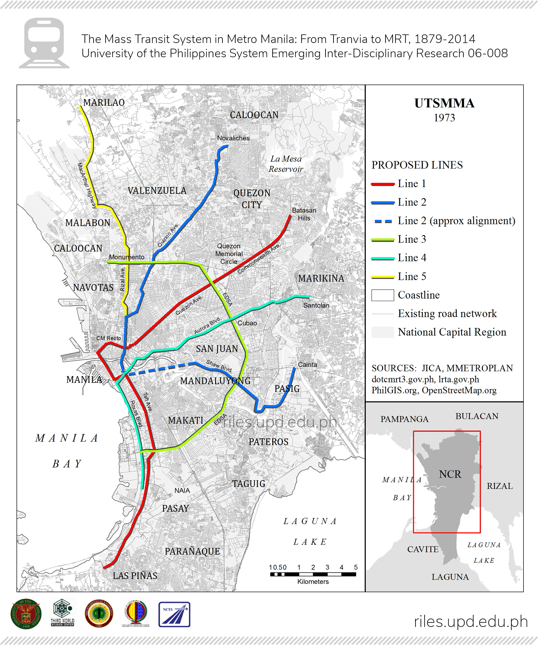
FIGURE 1. Proposed lines in UTSMMA (1973).
The UTSMMA proposed a long-term, rational solution to Metro Manila’s traffic problems, and would have taken 15 years to complete. UTSMMA may well have solved Manila’s traffic ills for many years to come, and opened up many potential business and residential centers outside of central Manila, including Marikina and Cainta in Rizal, and Marilao and Meycauayan in Bulacan. Many of the recommendations for the roads and development of the PNR lines were adopted, although would take time to carry out. Had the entire plan been carried out—including the subways—it would be finished in 1988. As with many such plans, pragmatic
considerations—mainly cost—were made, such that the subway component was not carried out. Apart from the extensive work required to dig tunnels and underground rail lines, land rights would have to be paid for and heavy rail cars would have to be acquired. Portions of the road plan and a modified version of Line 1—significantly shortened—would be carried out. But this line would be implemented under a new plan, based on a very different set of assumptions.
Instead of fully implementing UTSMMA, the Marcos administration instead commissioned the drafting of another plan, the Metro Manila Transport, Land Use and Development Planning Project or the MMETROPLAN. The study, conducted from 1976 to 1977, was funded by the World Bank, which in turn contracted the services of Freeman, Fox and Associates, working closely with ranking government officials. It was meant not only to address the traffic needs of Metro Manila, but also to complement First Lady Imelda Marcos’ ideas of the “City of Man”, ‘an environment within which man can develop his full potential, where any man can live fully, happily and with dignity’” (7). Mrs. Marcos was at this time Chair of the Metro Manila Commission.
MMETROPLAN disagreed with several of the assumptions and proposals of UTSMMA. For one, Freeman, Fox—and the World Bank—did not feel that the heavy rail transit advocated by the Japanese was suitable to Manila’s conditions. “It would be hopelessly uneconomic,” they concluded, arguing against any form of segregated mass transit system. Neither would upgrading PNR’s lines be cost effective (a sign of bias against the railroad); and MMETROPLAN advised against opening up the Marikina and Cainta areas along the eastern portions of the Metro Manila Area (MMA) as these would be prone to flooding (it recommended developing the Tandang Sora/Commonwealth Avenue and Parañaque/Sucat areas which were along the northern and southern parts of the MMA). MMETROPLAN, in fact, openly criticized UTSMMA. Instead, its proponents proposed the continued use of buses and jeepneys as a cheaper alternative.
Freeman, Fox conceded that mass transit would be useful, and recommended that four lines be developed. These lines would be light rail transit (LRT) lines, similar to the LRT system in Europe, which were modernized, rapid streetcars that ran on road level, were not segregated from motor transport, and followed traffic lights along with cars and buses. The MMETROPLAN lines radiated out of central Manila to the
north (to Monumento, through Rizal Avenue), northeast (to Quezon City, through Espana/Quezon Boulevard), southeast (to San Juan and Mandaluyong, via Shaw Boulevard) and south (to Makati and Pasay, via Taft Avenue, stopping just short of the airport), with a loop line serving the central area, including the ports and main business district. A map of the proposed lines under MMETROPLAN is shown in Figure 2.
While some of these lines overlapped with the UTSMMA plan, MMETROPLAN’s lines were generally shorter and more limited. As light rail trains go, capacity was smaller than heavy rail trains; somehow it seems Freeman Fox did not foresee the overcrowding that soon became a feature of Manila’s LRT (forecast for 1980 was 190,000 to 216,00 daily; by 1990, 301,000 to 330,000 [actual volume in 2010 was 430,000 a day]). Apparently, the main consideration of MMETROPLAN was cost: it openly compared UTSMMA’s HRT expenses with MMETROPLAN’s lower costs. MMETROPLAN aimed at constructing its lines between 1980-1985.
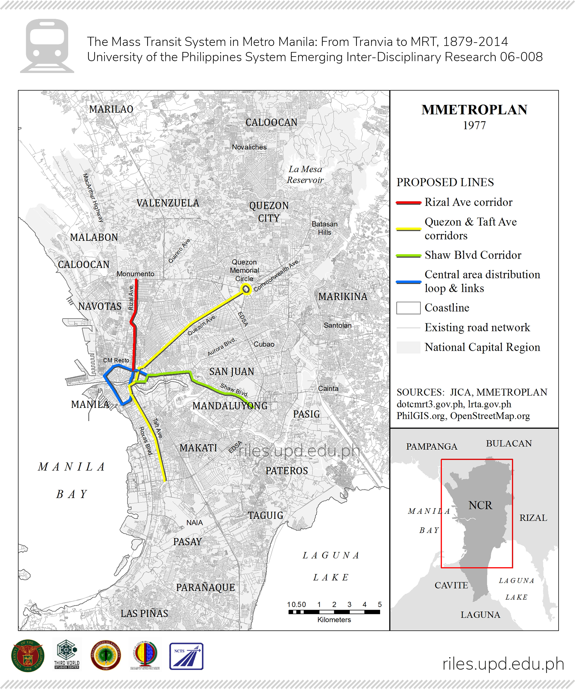
FIGURE 2. Proposed lines under MMETROPLAN (1977).
The Marcos government adopted the plan, but made changes along the way— an action that would recur in the construction of the actual routes and stations. Instead of a street level Light Rail system, LRT-1—paralleling part of UTSMMA’s Line
1 and the whole of MMETROPLAN’s Rizal Avenue corridor line—the Department of Transportation and Communications decided that the modified Line 1 would take the form of an LRT system segregated from road traffic. Unlike most LRTs in Europe, which were essentially modernized streetcars running on road level, the LRT-1 would be elevated, and would run 19.7 kilometers. The decision to segregate the LRT from road traffic (which was not part of the original MMETROPLAN) added to the initial cost, and a supplemental plan was drafted.
As MMETROPLAN was being crafted, a third plan was being developed by the Japanese, this time by the Japan International Cooperation Agency (JICA). JICA’s Feasibility Study for Manila Rapid Transit Railway Line 1 was an offshoot of the earlier UTSMMA, and went into details of its Line 1, running from Quezon City through Commonwealth Avenue, Quezon Boulevard, through the university belt, port areas, and Taft Ave, with possible extension to Baclaran and the airport. The study, a technical and economic report, was completed in June 1976 and went beyond just Line 1: it proposed five mass transit lines, essentially scaled-down versions of the UTSMMA plan, some elevated rather than underground. These lines are shown in Figure 3.
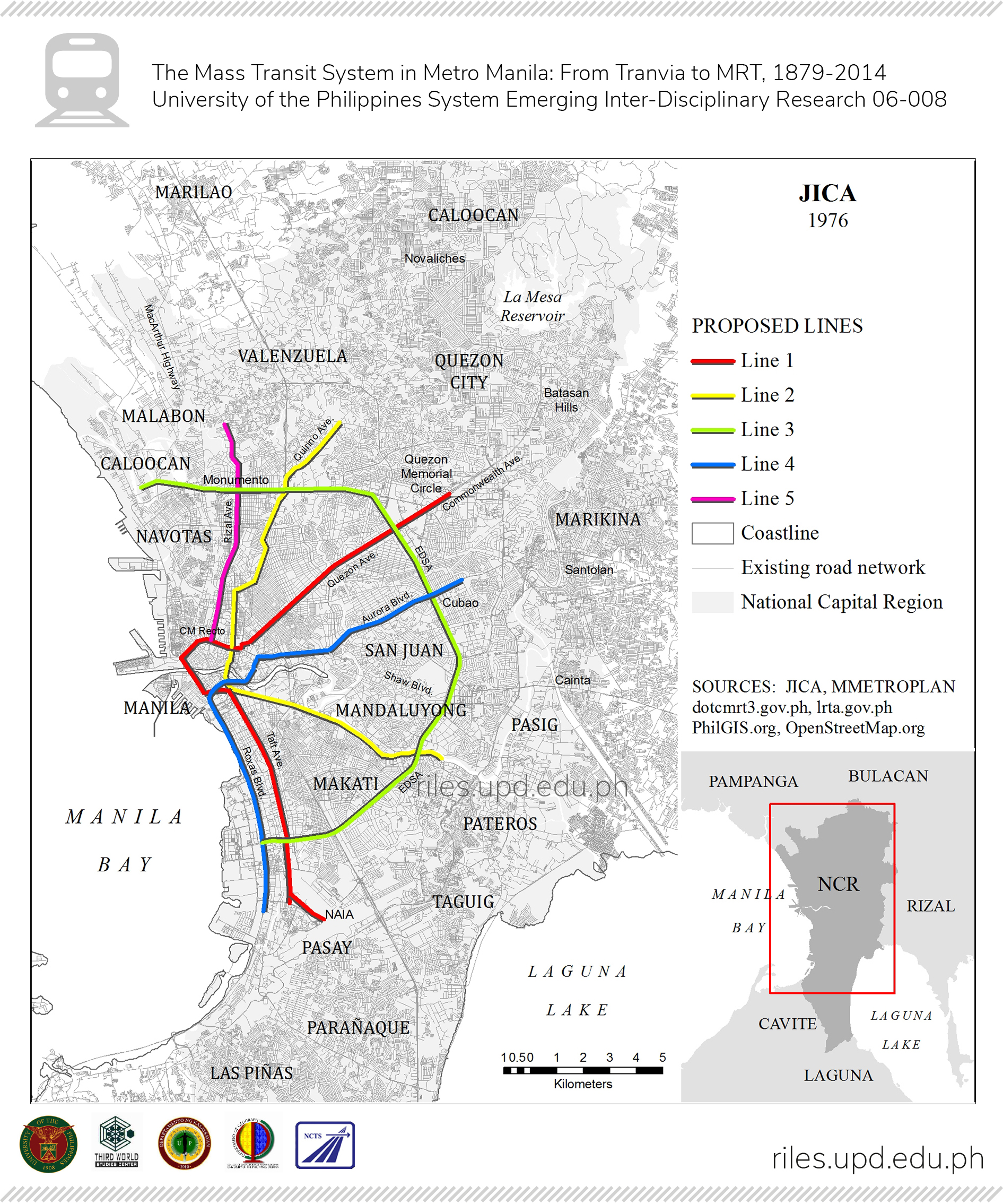
FIGURE 3. Proposed lines by JICA (1976).
The JICA study again recommended heavy rail, based on updated population projections (estimated at 5.7 million by 1987 and 7.5 million by 2000). It assumed that other urban centers would be developed in neighboring provinces, and that “population and land use patterns will change when the Rapid Transit Railway is constructed.” Line 1—and the subsequent lines— would be integrated with modernized PNR train services (upgraded to rapid transit) and bus and jeepney routes, which would bring people to the Rapid Transit stations. Due to financial and technical concerns, the JICA plan estimated construction of Line 1 to take ten to twelve years (planned completion in 1986 or 1988), and the other lines another fifteen years. JICA assumed that compromises would have to be made along the way, to adapt the 1970s plans to future conditions (8).
As noted above, however, the Marcos government adopted the MMETROPLAN’s recommendations, and took construction of LRT-1 as a government project. In July 1980, Marcos created the Light Rail Transit Authority (LRTA) through Executive Order 603. Imelda Marcos, concurrently governor of Metro Manila, became its first chairperson. Under this order, the LRTA would oversee operations of the LRT system (construction had not yet started at this stage), but day-to-day activities would be handled by a private corporation for a ten-year period.
The project was bid out, and the Construction and Development Corporation of the Philippines (later the Philippine National Construction Corporation) began construction in September 1981, with the help of a Belgian loan. Electrowatt Engineering of Zurich was appointed overseer to the project (5).
Initially, LRT-1’s cars were from Belgium. In line with MMETROPLAN’s stress on economy, these were Spartan, without air-conditioning. Passengers entered stations through turnstiles operated by LRTA tokens. A test run was held in March 1984, and eight months later, the first half (the southern section) was opened to the public. The northern half was officially opened in April 1985. Manila’s LRT-1 became the first mass transit system in Southeast Asia, and proved of immediate benefit to the commuting public who now had an alternative to the slow jeepneys running below. Financially, the LRT-1 was also reported as “among the best in the world” for some years (4).
Passenger demand for LRT-1 was higher than the cars could handle, and the trains quickly fell into disrepair due to overcrowding. Frequently they had to slow down lest they suffer damage. Some years later, they would be rehabilitated with the help of Japan; more modern air-conditioned cars would be introduced, but still limited by their LRT size.
As LRT-1 plans reached fruition, Metro Manila’s traffic continued to deteriorate. It was estimated that some 20,000 passengers passed per hour in one
direction in various major routes of the metropolis, and road vehicle movement was slowing down to an average of 18 kilometers per hour, with accompanying losses to businesses (4, 5). It became evident that additional mass rail transit had to be seriously considered.
What was then called the Philippine Ministry of Transportation and Communications (MOTC), in conjunction with Electrowatt Engineering Services of Zurich, jointly designed a plan to extend the light rail transit system. The study, the Metro Manila Light Rail Transit Network Extension Inception Report, dated December 1980, sought to “investigate the comparative feasibility of alternative LRT routes and operating strategies” and serve as a guide for transport policy decision makers. Electrowatt Engineering looked into identifying and evaluating a potential LRT network. Looking over existing plans, it concluded that the MMETROPLAN was the most comprehensive, but added that the eastern growth area (Rizal province) had to be taken seriously in future planning. Given potential population growth in the Marikina valley and surrounding areas, Electrowatt Engineering recommended that heavy rail or a monorail system (not LRT) be built accordingly. The expanded Mass Transit Rail (MRT) would be integrated with PNR, bus and jeepney routes, as well as the new highway construction then going on (Marcos Highway and the Cavite Coastal road). The study amplified the MRT routes of the previous plans, recommending a twenty-year time frame to develop some 150 kilometers of mass transit rails. The previous UTSMMA, MMETROPLAN and JICA plans were apparently combined in various forms in this plan.
The MOTC again commissioned another study, with Pak-Poy & Kneebone Pty. Ltd., which was completed in 1983 as the Metro Manila Urban Transportation Strategy Planning Project (MMUTSTRAP). This plan was partly supported by funds from the Australian Development Assistance Bureau (forerunner of AusAID). As in previous studies, MMUTSTRAP considered PNR commuter service to and from Manila, and noted that PNR, with which its limited budget and “the variety of problems” it faced, was deteriorating quickly. While it noted the eagerly awaited completion of LRT-1, MMUTSTRAP pessimistically predicted that mass transit rail would have to depend on sizable government subsidy to keep it in operation. It did not, however, propose any new routes or rolling stock, preferring to stick with LRT-1 and the planned LRT- 2 and MRT-3. At this point the bulk of the planning had been done already.
A year later still another study of Manila public transport was conducted by JICA. This was their 1984-1985 Update on Manila Study on Urban Transport: The Metro Manila Planning Study (JUMSUT I and II) Rather than proposing new lines,
JUMSUT aimed to simply provide updated information on bus and jeepney transport in Manila. LRT- 1 had just commenced operations and it was thus too soon to obtain information on its impact (9).
Planning and construction of further mass rail lines was delayed by the decline of the Marcos administration’s fortunes after the assassination of Benigno Simeon “Ninoy” Aquino Jr. in August 1983 (just as LRT-1 was nearing completion). Marcos’ ouster in February 1986 and the assumption of the presidency by Corazon Aquino temporarily halted any plans and projects, but by 1988 plans were underway once more. An initial feasibility study for LRT-2 (which would connect the Marikina Valley with downtown Manila via Aurora and Magsaysay Boulevards and C.M. Recto Avenue) was carried out in 1988. The Aquino administration bundled LRT-1 extension with the new LRT- 2 line and bid out the project as a Build-Operate-Transfer (BOT) scheme, under the newly signed BOT law. But the bidding failed, and the project hibernated for two years. It was resuscitated in 1991, when additional sources of funding were available. Before any bidding could be held, Mrs. Aquino’s term ended, and Gen. Fidel V. Ramos took over the reins of government. Ramos was determined to see the LRT-2 to fruition and made it one of his flagship projects. This time it was bid out as a stand-alone project, separate from the LRT-1 expansion plan. Construction began in 1996, but delays were experienced due to legal challenges and reports of irregularities in the bidding. These were eventually cleared and construction resumed in 2000. By this time there was a new president, Joseph Estrada. Construction of LRT-2 faced unexpected difficulties, legal and otherwise, causing delay. Compromises had to be made and alterations to the original plan in terms of station locations, actual route (due to land issues) and problems in planning and decision making (4, 5). Before LRT- 2 could be completed, Estrada would be ousted from power and it was thus his constitutional successor, Vice President Gloria Macapagal-Arroyo, who was the president who inaugurated the first phase of LRT-2 in April 2003. The line was fully operational by October 2004 (4). Figure 4 shows a map presenting the evolution of proposed and existing rail lines in Metro Manila.
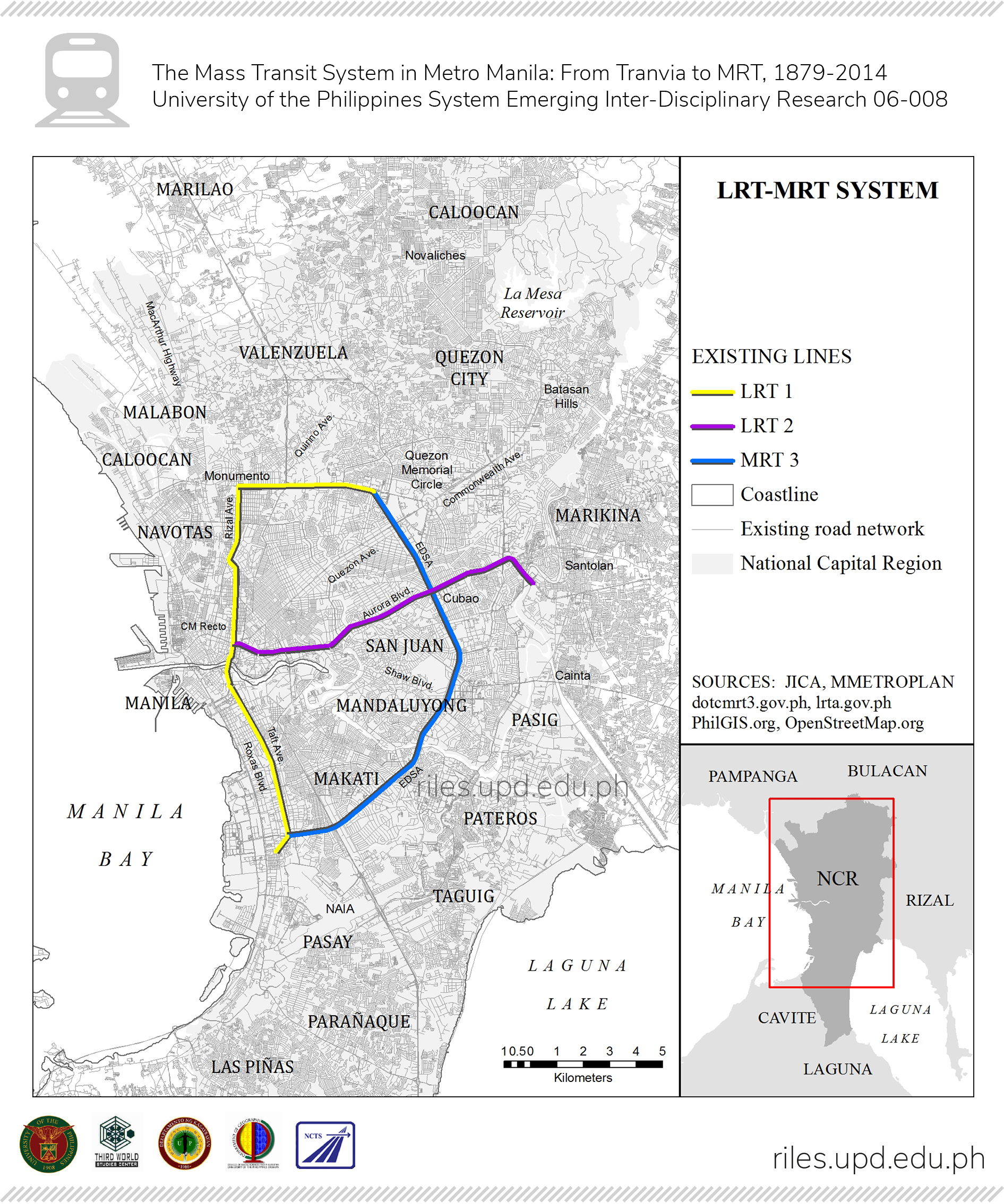
FIGURE 4. Alignment of proposed and existing lines in Metro Manila.
While LRT-1 was built according to MMETROPLAN as modified by what was by then again called the Department of Transportation and Communications (DOTC), LRT-2 would be built with closer Japanese support, as a heavy rail rapid transit system. JICA had now found its niche in the Metro Manila mass transit system and could thus implement part of its 1976 plan. Although there were also American, British and other consultants, the Japanese presence was very obvious: Japanese official development assistance, Japanese banks, and Japanese engineers all played a role in the construction of LRT-2. Cars came from either Japan or South Korea, and the more advanced technology of LRT-2 as compared to LRT-1 and MRT-3 are obvious to anyone riding the trains. As heavy rail, passenger capacity is greater than any of the other lines. The system is also more advanced than the other two lines. Ironically, LRT- 2 handles relatively less passenger traffic than the other two lines, partly because it has not been extended to the original terminals of the line, which will ensure more passengers. An extension project was approved by NEDA in 2012 (4).
LRT-1 and LRT-2 are both run by the LRTA, a government agency. MRT-3, however, is another story in terms of concrete planning, construction and operation. While the route of MRT-3 was part of the UTSMMA and JICA (1976) plans, the Aquino administration planned to build MRT-3 along the EDSA route as early as 1989. The DOTC decided to build the MRT-3 as a BOT project, and entered into an agreement with the Hong Kong based EDSA LRT Corporation (later renamed the Metro Rail Transit Corporation or MRTC; this was a consortium of ten companies, both foreign and Philippine). President Ramos approved the agreement in May 1993, which also provided for the provision—as a gift to the Philippines—coaches from the Czech and Slovak Republics.
Since MRT- 3 could be seen as a public utility, and MRTC a foreign firm, in 1995, three senators sued the DOTC, alleging that the agreement was illegal and unconstitutional, and disadvantageous to the government. (The Philippine Constitution prohibits foreign corporation from owning public utilities). The Supreme Court dismissed the charges, and allowed the agreement to stand. The Ramos administration then approved the revised plans, and construction began, only to face additional delays caused by the Asian Economic Crisis of 1997.
Essentially MRT-3 followed Line 3 of the JICA 1976 plan, with changes due to buildings, flyovers, and road layouts very different from the time of the original plan. Negotiations for land, locations of stations, right of way, and other settlements had to be negotiated. Due to space constraints, escalators were removed from the plans, but a loud public outcry forced their inclusion. Finally in December 1999, the first phase of MRT-3 was inaugurated by President Joseph Estrada. By July 2000, the entire line was in operation (10, 4). Further problems would be faced by MRT-3, but these are beyond the scope of this paper.
With three lines running separately, there has been no lack of plans to integrate the lines. Transfer stations were established, but some require long walks amidst thick crowds. LRT-1 was extended from Monumento to Roosevelt Avenue, although it did not connect with MRT-3; it thus seems like a dangling appendage to the first mass transit line. This extension was not part of any of the earlier plans and appears to have been a later modification. The existing lines, with the three major plans superimposed, are shown in Figure 4. Plans to standardize tickets, and “close the loop” to create an unbroken line have been announced. A 2001 JICA study was one of the many plans drawn up, drawing on the Japanese experience to link not just the LRT/MRT lines but also the PNR lines, which had been part of earlier plans. Further plans to extend the lines have been drafted, some of them already having been approved by NEDA; some of these had already been on paper as early as 1973. Target dates for completion have already been set, but as of now, construction has not yet begun. Several other evaluations were conducted, among them one in 2008-2009 under the auspices of Sanshu Engineering Consultation. A year left before the end of Benigno Simeon “Noynoy” Aquino III’s term, portions of these plans began to be implemented.
There have been several plans to develop a mass rail transit for Metro Manila. However, some of these plans were based on assumptions which reflected the different interests of the stakeholders involved and which were not necessarily congruent. By utilizing parts of several plans and not sticking to one plan, the overall fundamentals were thus negated, resulting in confusing if not conflicting assumptions and infrastructure. The three existing LRT/MRT lines are not integrated, and swerved from the original designs due to a variety of factors. One analysis noted that the “strategies are [developed, but are] not always implemented or effective” (4). It is realized that plans were influenced by people and events during the period when these were formulated. The plans also reflected the thinking of the framers, and later planners criticized or disagreed with the basic premises as well as the proposed projects of previous studies. Making things more complicated were pragmatic— particularly cost—considerations, political will and the possible influence of funding and construction agencies. Such lessons learned from these past planning exercises that yielded rail transit master plans for Metro Manila should be revisited by current planners in order to properly understand the evolution of mass transit in Metro Manila. This is necessary in order to come up with the proper context for further planning and eventual implementation of such plans for rail-based mass transit, in light of the urgency to build such infrastructure to address the worsening transport problems faced by the Philippines capital region.
This work was funded by the UP System Emerging Inter-Disciplinary Research Program (OVPAA-EIDR-06-008).